
Sizing Up the Sea Ice
- Sarah Johnson
- Mar 31, 2023
- 2 min read

Updated: Apr 13, 2023
Happy International Polar Week! I wrote a poem to contribute that reflects on my time in 2022 on the Arctic sea ice.

Scales of Sea Ice
Studying sea ice happens at many geographic scales. Most folks hear about the Arctic Ocean in the context of declining sea ice and climate change. These large scale reports generally refer to the Arctic Ocean as a whole (the geographic size of the Lower 48 states).
In Utqiaġvik Alaska, like many other small coastal villages in the Arctic, the people are and have been living with the sea ice and all that it provides since time immemorial. It is not until recent decades that satellite, radar, and other remote sensing types of images are so accessible.
While here at the sea ice in Utqiaġvik, the we think globally, yet must respond hyper locally to the sea ice conditions. Buoy data contributes to the larger planetary understanding of how ocean currents circulate. And to deploy the buoys in the best multiyear sea ice locations, the team has to carefully study the hyper local sea ice conditions to ensure safe deployments for everyone involved.
At the very local level, community members rely on the Utqiaġvik sea ice radar to closely monitor sea ice floes offshore. The team also monitors the radar to ensure the deployment sites of the buoys. During the last day or two the floes have been rather active and exciting to watch. Click the radar image below to view the recent activity.
At the ocean wide scale, scientists and researchers study Arctic sea ice using satellite imagery along with the observation data from the buoys on the sea ice to better understand sea ice movement and circulation. This data can be visualized on the IABP map visualization (click the map to open) below.

All the geographic scales and scales of time are important to understanding the broader Arctic Ocean system and sea ice behavior. Though it can be complex and challenging to grasp, the local elder observations paired with all the technological advances allows us all to better understand how the planet works within the Arctic region.
Meanwhile Here in Utqiaġvik with a Collective of Collaborators
I was fortunate to assist with the annual 8th grade sea ice field trip today after its four year hiatus. Students interacted with Iñupiaq elders and sea ice scientists from many disciplines.
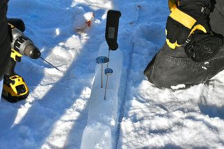
The students explored and made many different types of sea ice observations including remote sensing with GoPro cameras attached to kites, flying drones 400 feet above the ice, measuring sea ice thickness, temperature of the sea ice profile, learning about the creatures that live in the brine channels at the base of the sea ice, and learning the traditional Iñupiaq ways of understanding and talking about sea ice features and observations.
The weather was incredibly suitable (7°F, 10mph wind, and sunshine) for a field day on the ocean sea ice. We couldn't have asked for a better day.
The Arctic Sounder news and media folks covered the event.


I thoroughly enjoyed going through your work on sea ice dynamics—it's such an important issue today. In my search for sources to use for my own college research on climate change, I was having a tough time finding trustworthy sources. That's when I came across College Assignment Help Online—a godsend for students like me! Their professionals assisted me in organizing my research and refining my arguments so that complicated subjects became easier to understand.